


Etape 7 - GRR2

Ko-Rando
User

Length
14.5 km

Max alt
2070 m

Uphill gradient
877 m
Km-Effort
28 km

Min alt
904 m

Downhill gradient
1299 m
Boucle
No
Creation date :
2025-06-11 03:49:14.877
Updated on :
2025-08-05 08:32:29.575
5h39
Difficulty : Difficult

FREE GPS app for hiking
 SityTrail
IGN / Geographical institutes
SityTrail Plus
The world is yours!
About
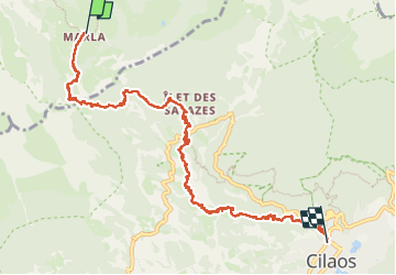
Trail Walking of 14.5 km to be discovered at Réunion, Unknown, La Possession. This trail is proposed by Ko-Rando.
Description
De Marla à Cialos en passant par le col du Taïbit.
Si vous voulez vous baignez, ne suivez pas ce tracé et prenez la bifurcation un peu après avoir traversé la route.
Positioning
Country:
France
Region :
Réunion
Department/Province :
Unknown
Municipality :
La Possession
Location:
Unknown
Start:(Dec)
Start:(UTM)
337386 ; 7665666 (40K) S.
Comments